


Make sure the avoid motorway is turned off in settings
I also used mine for the first time today (Rider 500) and it was an adjustment from google navigate. I also missed about 3 turns as the turn distance is a bit misleading. It looks like its 50 meters away and boom turn left. Also I made the mistake of letting it plot a winding return loop from reading to fishhill, it took me through every farm and country road on the planet, which anything more than 10 mph will result in a spill. In the end I just gave up and returned home.
Also the syncing between mydrive and the device seems a bit iffy, I created routes on the site but they did not appear on the device, need to get to the bottom of it. Think I need to sit with it for a couple hours and figure everything out.
Also the syncing between mydrive and the device seems a bit iffy, I created routes on the site but they did not appear on the device, need to get to the bottom of it. Think I need to sit with it for a couple hours and figure everything out.Did you tell MyDrive to sync them? That one got me at first. After uploading a route you need to click on it in My Routes list. That gives a sync option (and nothing else) which is disabled by default. A really stupid interface as it is not obvious that you can click on them, you need that extra step for just one option, and who would upload routes then not use them? You cannot even chose the default in the settings, it seems you have to set it every time.
kcoops
Mine is just the 420, from the big deal Amazon had recently, but I am happy overall. Will just have to get used to keeping track of the time to know how long I have been riding. Or strap a stop watch to the bars!
Bigty, I wanted to use the motorway! It was a route I had created and had already had fun on the A, B, and unclassified roads, so was now aiming to be home around 12:30. If I had taken the original M20 route it was estimating around 12:40, which would have been fine, just the south circular is always best avoided. The recalculated M26/A23 one I ignored was the same, but the longer A217 way it correctly estimated as saving me ten minutes. So local knowledge still counts for something!
So the only sync option I can see is "Sync this route as a track in my devices". Is that what you are referring to? If so you are right its a bit daft, because when you are on the device when looking at a route, it is not necessarily a "track". Also if that is the only place it can be synced, that explains me standing for near 20 mins in the middle of nowhere trying to re plot on my mobile and for the life of me couldn't find a way to sync back to the device. But there are definitely some functionality that automatically syncs just need to figure out definitively which.Also the syncing between mydrive and the device seems a bit iffy, I created routes on the site but they did not appear on the device, need to get to the bottom of it. Think I need to sit with it for a couple hours and figure everything out. kcoopsDid you tell MyDrive to sync them? That one got me at first. After uploading a route you need to click on it in My Routes list. That gives a sync option (and nothing else) which is disabled by default. A really stupid interface as it is not obvious that you can click on them, you need that extra step for just one option, and who would upload routes then not use them? You cannot even chose the default in the settings, it seems you have to set it every time.
Mine is just the 420, from the big deal Amazon had recently, but I am happy overall. Will just have to get used to keeping track of the time to know how long I have been riding. Or strap a stop watch to the bars!
Bigty, I wanted to use the motorway! It was a route I had created and had already had fun on the A, B, and unclassified roads, so was now aiming to be home around 12:30. If I had taken the original M20 route it was estimating around 12:40, which would have been fine, just the south circular is always best avoided. The recalculated M26/A23 one I ignored was the same, but the longer A217 way it correctly estimated as saving me ten minutes. So local knowledge still counts for something!
Michael
Some seriously long replies!
So I went full elevation, 2nd (out of 3) twisty, said no motorways and must have tarmac.
And I had a cracking ride, next time which is this coming weekend me and a mate will be going rye on the same settings only adding a couple of stop offs on the way…
Best purchase I’ve made…
Do you mind sharing the gpx file
So the only sync option I can see is "Sync this route as a track in my devices". Is that what you are referring to? If so you are right its a bit daft, because when you are on the device when looking at a route, it is not necessarily a "track". Also if that is the only place it can be synced, that explains me standing for near 20 mins in the middle of nowhere trying to re plot on my mobile and for the life of me couldn't find a way to sync back to the device. But there are definitely some functionality that automatically syncs just need to figure out definitively which.Yes. That needs to be enabled to see it on the TomTom. And even I had to go in and out of the menu on the TomTom a few times last night before it appeared.
kcoops
Because MyDrive calculates a “track” (an actual route) for the “route” (just the way points) it syncs the track rather then the route. Which does make sense, as there is no point MyDrive calculating a specific route only to then ignore it and make the device have to calculate it again.
That seems to be the only way I can see to get anything onto the device other than using an SD card, which I have not tried yet but may end up being easier. But that way you should be able to upload routes as ITN files, as well as tracks in GPX ones.
Getting round France this week I used a book, with lots of drawings of towns, roads with numbers. Was fookin brilliant  #oldskool
Disclaimer first, I’m probably the least tech savvy on here.
The easiest way I found to sync my TomTom Rider 400 was with the TomTom connected to mobile via bluetooth, note the mobile needs to be connected to internet, it can also be done by connecting the TomTom to a PC or lap top via the USB cable but for some reason this doesn’t always sync at the first attempt. I have a SD card in mine and have selected save routes/tracks to SD card but it doesn’t appear to do this.
For winding roads I now only use the 1 setting having found 2 and 3 can take you proper off piste and down some undesirable roads just because they have a bend or two in them.
Got mine from SportsBikeShop on a £200.00 and would thoroughly recommend.
Getting round France this week I used a book, with lots of drawings of towns, roads with numbers. Was fookin brilliant :-) #oldskool bluelagosYou was in a car though ya faker!!
Still reckon one of them light Michellin ones is the bollox. Planning routes and when you go wrong. The Jets used to pack a big road map. Reckon I might start photographing pages I need, now that I’ve worked out how to photo things. ![]()
If you've synced the phone and headset with the TomTom as well as the headset (Sena5) and phone, disconnecting the latter may help. I always disconnect the TomTom and Headset Bluetooth connections on my phone and reconnect so that TomTom gets the first phone channel. I think two channels are phone and media and the first connection gets the phone one. If the TomTom ends up on the media channel the audio is really bad. Unless you need music from your phone best disconnect it from the headset TomTom and phone will try and service incoming calls.
... Bluetooth sound quality is pretty awful ....
Michael
I have a Scala Q3 with the phone on channel 1 (for music) and the TomTom on channel 2. The phone is just connected to the TomTom for network sharing only, not voice. I do not make calls when off the bike (I am not a caveman!) so seemed better to not bother.
Never though the channels may matter though so will experiment and see if switching the order on the Scala helps. I am sure the problem is bluetooth related as sometimes it drops words or just makes weird sounds.
Thanks for the advice.
Latest review on the TomTom is I have now found out how to copy tracks over USB from a Mac, without needing an SD card or using the MyDrive web site and syncing. You just need to download a free program called Android File Transfer, open the MyDrive desktop app first, then drag and drop in the Android one. Definitely easier than uploading GPX files, making them syncable, connecting the TomTom to my phone, then forever going in and out of my routes until they appear.
Wishing there was an overview map in the corner, or somewhere, giving a simple flat view to go with the 3D one, just so you can see what is upcoming. The 3D view can be a bit confusing when you have weird junctions with lines going everywhere, especially when some of them are a tunnel underneath you.
Would also be nice if if used different colours for a track being followed, and a route it computed itself. My track for today had several little detours to supermarkets for petrol and shopping, so I could pick the appropriate one for when I needed to stop. But after skipping one of them I thought I had got lost, as in recalculating the route to double back it removed section of the track I was now on.
(That was for Colchester Sainsbury’s, in the end I went to Maldon Tesco and ate mango and watermelon in the car park.)
Also it does not cope with double mini roundabouts very well, the voice instructions for the second one always come after I have already exited it. It really needs to treat them as a single entity rather than separately one after the other. I dread to think how it would cope with the Magic Roundabout.
Biggest problem though is it has made my bike go faster. Hmph. What on the speedo used to make me slow down, the TomTom says is within the 10% + 2.
I never listen to TomTom voices, just visually note the next turn indicators and they’re pretty much spot on +/- half a yard

Is it normal for a TomTom to punish you?
I was using an uploaded GPX route I had made. I should have simply stayed on the A40 to Burford, then onto the A361 when they meet. Instead it told me to turn off the A40 to Little Barrington, then take a gravel covered single track lane (with the gravel covered in moss) to Burford. And even after turning onto the A361 there, it still wanted me to go off and do other weird stuff to get to the A40 junction had I not been so confused by it sending me into a random residential street that I missed the turning.
A little later I am going from Carterton to Faringdon on the B4020, which becomes the A4095 when that arrives at a junction. Only it tells me to turn off at that junction, takes me into Bampton, sends me to a residential street, then tells me to do a U-turn and go all the way back to the junction to rejoin the road I was on!
Earlier it also decided to skip a section to a car park and sent me straight through town. I guess it does not like Worcester.
Meanwhile whenever I encounter a closed road it never reroutes to avoid that, and instead just pesters me to go back whilst I follow the signed diversion.
There are three issues that may cause that
-
Way points - check your way points. If you don’t zoom in enough when making the route its easy to have a way point just off where you really want it to be. I use ITN Converter to plan routes and zoom right in to max zoom to check that the way points are exactly placed right where they need to be.
-
Mapping or file format compatibility where you plan the route on one map or convert the file from another format the end result can sometimes be a compromise when TomTom plots the the route, always zoom right in on the way points after compiling or converting route files to be sure to be sure.
-
Windy roads setting. Selecting the last way point of a route file as the destination while in the plan a thrill mode. Depending on the windy roads setting you could end up going any which way to get where you want to be, its not a very good feature once you go beyond the first windy road setting.
My preferred map for planning route files is OpenStreetMap which in conjunction with ITN Converter appears to be perfectly compatible with all my TomTom Sat Navs (TomTom Rider, TomTom One and TomTom XL). It works fine compiling or converting TomTom itn files, TomTom ov2 files or GPS eXchange (gpx) files. I’ve also successfully used ITN Converter to convert Garmin files to TomTom compatible itn, ov2 and gpx files.
but if it’s following a pre planned route it will take you that route …
check your points and that the route settings match device and what you planned it on ie shortest/ quickest .
Yes, it should be following that preplanned route, which is why I am totally confused by what happened.
I was using a GPX file which I created (home made app using Google’s API), so no conversion issues. And it is what TomTom calls a track. i.e. it has no waypoints, is instead just a list of points every hundred yards or so, and should be followed directly rather than the TomTom itself calculating anything. And I also always zoom in to check the points are in the correct place when I create the file. At least I have done ever since it tried to get me to turn onto people’s driveways!
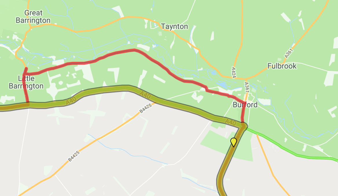
Here is the Burford example, the yellow line is the GPX track I created, and the red line is where it recorded that I went. Had I not missed the turning, the TomTom wanted me to follow the white line further to the east of Burford which eventually joins the A40, then head back west on that to the A361 junction.
As you can see the only pin I added to create the track was on the A361, the previous one was where I joined the A40 sixteen miles back, so no issues of me causing it. And checking the GPX file there were 263 of calculated points along that section, and there were also no traffic problems to need to avoid, so no reason for the TomTom to have had to calculate anything there.
This has not happened before, but it makes it a little difficult to trust it when I cannot understand what happened. It is normally so faithful to a route, as I said trying to force me to use closed roads, yet here it completely ignored the route.
Attachments
I do know that with the ongoing heat that gps satellite fixes are a bit wayward .My hgv one is having issues staying on roads .